
Working with an existing building presents a challenge that often appears before design even begins: the available documentation does not always represent what actually exists on site.
Original drawings may be incomplete, outdated after multiple renovations, or may simply fail to record modifications carried out over years of operation.
In these situations, making decisions based only on historical drawings and manual measurements can introduce uncertainty from the earliest stages of the project.
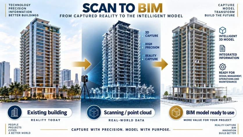
The Scan to BIM methodology makes it possible to begin with a digital representation of the actual building conditions and use that information as the basis for developing a BIM model.
The goal is not simply to obtain a three-dimensional image of the property. The real value lies in transforming field-captured information into a structured model that can support design, coordination, renovation, As-Built documentation, and project management.
Trimble describes Scan to BIM as the process of capturing real-world conditions through 3D scanning and then using that data within a BIM environment, while Autodesk highlights its usefulness for understanding existing buildings, renovation projects, and adaptive reuse.
What Is Scan to BIM?
Scan to BIM is a workflow that combines reality capture technologies with BIM methodology.
The process typically begins with a 3D laser scanner or another capture technology capable of recording millions of spatial points.
Each point contains coordinates representing a specific position on an existing surface. When millions of these points are combined, they create what is known as a point cloud.
A point cloud can digitally represent existing geometry such as:
- walls and columns;
- slabs and roofs;
- doors and windows;
- pipes and ducts;
- equipment;
- interior spaces;
- façades;
- structural elements.
This information is then processed and used as a reference to build a BIM model representing the actual conditions of the project.
Trimble explains that scanning allows teams to capture existing conditions efficiently and later use that information to create As-Built models, verify completed construction, or supplement missing design documentation.
From Point Cloud to BIM Model
Although the terms are sometimes used interchangeably, a point cloud is not yet a BIM model.
A point cloud primarily represents captured geometry.
A BIM model, on the other hand, organizes that geometry into identifiable and structured objects such as walls, columns, doors, pipes, equipment, and other components that can later contain additional information.
A typical Scan to BIM workflow includes several stages.
1. Define the Purpose of the Survey
Before any scanning begins, it is necessary to determine how the information will be used.
A model intended to study the architectural layout of a building does not require the same level of detail as a model used to coordinate mechanical systems inside a technical room.
The capture strategy should therefore respond to the actual project scope.
Trimble emphasizes that defining the purpose of the data before scanning helps teams plan the capture more effectively and avoid collecting unnecessary information.
2. Capture Existing Conditions
The scanner records millions of visible points from different positions.
Because these systems work through line of sight, multiple scanning positions are normally required to represent the space properly and minimize hidden areas.
The result is a collection of partial scans that must later be combined.
3. Register and Process the Point Cloud
The different scans are aligned within the same coordinate system to create a consolidated point cloud.
This stage is essential because an incorrectly registered point cloud would transfer those errors into the BIM model.
4. BIM Modeling
Once the point cloud has been processed, BIM specialists use it as a reference to digitally reconstruct the relevant building elements.
Depending on the scope, the model may include architecture, structure, MEP systems, or other project components.
Autodesk has documented workflows in which scan data is processed and then used to create As-Built BIM models in platforms such as Revit.
5. Validate the BIM Model
Creating the model should not be the final step.
A good practice is to compare the completed BIM model back against the original point cloud to verify that the modeled geometry accurately represents the captured conditions.
Modern tools can visualize differences between the BIM model and measured reality through deviation analysis.
Leica Geosystems, for example, documents Point Cloud vs. BIM Model workflows that support deviation analysis, tolerance verification, and As-Built validation.
Why Is Scan to BIM Especially Useful for Renovation Projects?
Renovation projects present a challenge that is less common in completely new construction: the design must adapt to a physical reality that already exists.
And that reality may differ considerably from the available drawings.
A column that is slightly out of position, a pipe installed along a different route, or a lower-than-documented ceiling clearance can turn a seemingly simple design decision into a construction conflict.
Scanning allows designers and engineers to begin their work using current information about the building.
Leica Geosystems notes that buildings undergoing renovations may accumulate years of undocumented changes, while reality capture systems can record those conditions before major design decisions are made.
Fewer Site Visits and Better Access to Information
One of the major benefits of a well-planned reality capture process is that a large amount of dimensional information becomes available digitally.
Instead of repeatedly returning to the building to verify specific measurements, project teams can consult the point cloud from the office.
This does not mean that Scan to BIM completely eliminates site inspections. It means that it reduces dependence on repetitive manual measurements and provides a much more complete spatial reference.
Trimble identifies reduced return visits and faster data collection as two important benefits of the Scan to BIM process.
Scan to BIM and As-Built Documentation
Another major application of Scan to BIM appears at the completion of construction.
The design model represents what was intended to be built.
An As-Built model should represent what was actually built.
By performing post-construction scans, teams can compare installed systems and constructed elements with the BIM model and update final documentation.
This information can later support:
- future renovations;
- operations and maintenance;
- coordination of new installations;
- space evaluation;
- planning of future interventions;
- asset management.
Autodesk and Leica both document reality capture applications for As-Built documentation and verification of completed conditions.
Scan to BIM as a Construction Control Tool
The methodology does not need to be limited to the beginning or end of a project.
Periodic scans during construction can allow teams to compare actual site conditions with the digital model.
This can help detect deviations before they are concealed by finishes or later installations.
For example, the position of structural elements or MEP systems can be verified before additional work makes corrections more difficult.
Leica Geosystems documents this type of workflow using recurring scans, BIM overlays, and deviation analysis to verify that installed elements match the intended design.
Model Accuracy Should Match the Purpose of the Project
One of the most common mistakes is assuming that every Scan to BIM project should produce the most detailed model possible.
In reality, more information does not always mean greater value.
The required level of detail should be defined according to the decisions that will be made using the model.
An architectural project may need highly accurate representation of walls, openings, and levels, while an MEP intervention may require much more detailed capture of pipes, ducts, cable trays, and equipment.
Modeling information that will never be used increases time, cost, and file size without necessarily adding value.
For this reason, the project scope should clearly define which elements will be modeled, how they will be used, and what tolerances are required.
From Measuring a Building to Understanding It Digitally
Scan to BIM represents more than replacing a measuring tape with a laser scanner.
Its real potential emerges when captured information is integrated into a structured BIM process.
The point cloud records reality.
The BIM model organizes that reality.
Together, they allow architects, engineers, contractors, and owners to work from a common reference that is much closer to the actual conditions of the project.
For renovations, additions, As-Built documentation, and projects where existing geometry directly affects design decisions, starting with reliable information can become one of the most important decisions in the entire project.
At FENIX SMART BUILD LLC, the integration of BIM modeling, digital coordination, and existing-condition analysis allows us to develop models aligned with the real needs of each project, avoiding unnecessary modeling and focusing effort on the information that truly supports design, coordination, and construction.